Monthly Archives: July 2011

Mount Bromo

Standard
Mount Bromo

Mount Bromo

Mount Bromo

From Wikipedia, the free encyclopedia

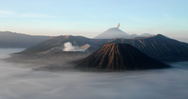
Mount Bromo (Indonesian: Gunung Bromo), is an active volcano and part of the Tengger massif, in East Java, Indonesia. At 2,329 metres (7,641 ft) it is not the highest peak of the massif, but is the most well known. The massif area is one of the most visited tourist attractions in East Java, Indonesia. The volcano belongs to the Bromo Tengger Semeru National Park. The name of Bromo derived from Javanese pronunciation of Brahma, the Hindu creator god.

Mount Bromo sits in the middle of a vast plain called the “Sea of Sand” (Javanese: Segara Wedi or Indonesian: Lautan Pasir), a protected nature reserve since 1919. The typical way to visit Mount Bromo is from the nearby mountain village of Cemoro Lawang. From there it is possible to walk to the volcano in about 45 minutes, but it is also possible to take an organised jeep tour, which includes a stop at the viewpoint on Mount Penanjakan (2,770 m or 9,088 ft) (Indonesian: Gunung Penanjakan). The best views from Mount Bromo to the Sand Sea below and the surrounding volcanoes are at sunrise. The viewpoint on Mount Penanjakan can also be reached on foot in about two hours. From inside the caldera, sulfur is collected by workers.

Culture

On the fourteenth day of the Hindu festival of Yadnya Kasada, the Tenggerese people of Probolinggo, East Java, travel up the mountain in order to make offerings of fruit, rice, vegetables, flowers and sacrifices of livestock to the mountain gods by throwing them into the caldera of the volcano. The origin of the ritual lies in the 15th century legend where a princess named Roro Anteng started the principality of Tengger with her husband, Joko Seger. The couple were childless and therefore beseeched the assistance of the mountain gods. The gods granted them 24 children but stipulated that the 25th child, named Kesuma, must be thrown into the volcano as human sacrifice. The gods’ request was implemented. The tradition of throwing sacrifices into the volcano to appease these ancient deities continues today and called Yadnya Kasada ceremony. Though fraught with danger, some locals risk climbing down into the crater in an attempt to recollect the sacrificed goods that believed could bring them good luck.

On the Segara Wedi sand plain sits a Hindu temple called Pura Luhur Poten. The temple holds a significant importance to the Tenggerese scatter across the mountainous villages such as Ngadisari, Wonokitri, Ngadas, Argosari, Ranu Prani, Ledok Ombo and Wonokerso. The temple organized annual Yadnya Kasada ceremony which lasts for about one month. On the 14th day, the Tenggerese will congregate at Pura Luhur Poten to ask for blessings from Ida Sang Hyang Widi Wasa and God of Mahameru (Mount Semeru). Then the mass will proceed along the crater edges of Mt Bromo where offerings will be thrown into the crater. The major difference between this temple with the Balinese ones are the type of stones and building materials. Pura Luhur Poten uses natural black stones from volcanoes nearby, while Balinese temples mostly made from red bricks. Inside this pura, there are several buildings and enclosures aligned in Mandala zone composition

Activity

[edit] 2004 eruptions

Mount Bromo erupted in 2004, that eruptive episode led to the death of two people.[citation needed]

[edit] 2010 eruptions

On Tuesday, 23 November 2010, 16.30 WIB (Western Indonesian Time), the Indonesian Centre of Vulcanology and Geology Hazard Mitigation (CVGHM) confirmed the activity status of Mount Bromo at “alert” due to increasing tremor activity and shallow volcanic earthquakes at the mountain.[4] Concerns were raised that a volcanic eruption may be likely to occur. As a precaution local residents and tourists were instructed to remain clear of an area within radius three kilometres from the caldera and refugee encampments were erected. The area surrounding the Teggera caldera of Bromo remained off limits for visitors throughout the remaining part of 2010.

Bromo started to erupt ash on Friday 26 November 2010.[5]

On 29 November 2010 Transport Ministry spokesman Bambang Ervan announced that Malang’s domestic airport, would be closed until 4 December 2010. Malang a city of about 800,000 people is about 25 km (16 mi) west of Mount Bromo. Abdul Rachman Saleh Airport IATA:MLG normally handles 10 daily domestic flights from the capital Jakarta. Government volcanologist Surono reported that the volcano was spitting columns of ash some 700 metres (2,300 feet) into the sky.

2011 eruptions

Bromo eruption January 22, 2011 at 5:30 am (Bromo volcano crater itself is not visible)

The Tengger Caldera was still active in late January 2011, the activity being characterised by fluctuating ongoing eruptions. On 23 January 2011 the Indonesian Centre for Volcanology and Geological Hazard Mitigation (CVGHM) (Pusat Vulkanologi dan Mitigasi Bencana Geologi) reported that since 19 December, 2010 volcanic ash and incandescent material had been thrown up by eruptive activity resulting in a heavy rain of material that fell around the crater. Continuous eruptions on 21 January caused a thin ash fall mainly in the village areas of Ngadirejo and Sukapura Wonokerto in Probolinggo district. The impact of a heavy rain of volcanic ash from eruptions since 19 December 2010 resulted in disruption of normal activities. By early 2011 concerns were being raised concerning the effect upon the local economy and the potential for long term environmental and health problems amongst the residents in the locality surrounding Mount Bromo. Due to high seasonal rainfall in January 2011 the potential for lahar and lava flow was raised due to the deposits of volcanic ash, sand and other ejected material that had built up. Seismic activity was dominated by tremor vibration and reports of visual intensity and sounds of eruption continued to be reported from the mountain monitoring facility, Bromo Observation Post. People living on the banks of the Perahu Ravine, Nganten Ravine and Sukapura River were alerted to the possibility of lava flows, especially when it was raining heavily in the area around Cemorolawang, Ngadisari and Ngadirejo. Eruptions and volcanic tremors were reported on 21 January and 22 January with activity subsiding on 23 January 2011. On 23 January, 2011 at 06:00 am the alert status at Mount Bromo remained at (Level III).[7]

On 23 January 2011 an exclusion zone was recommended for communities living around Mount Bromo. Tourists and hikers were to advised not to come within a radius of 2 km from the active crater. CVGHM stated that they expected warning signs to be installed stating the limit radius of 2 km from the crater. Operational caution was recommended for flights into and leaving Juanda International Airport IATA:SUB in Surabaya. CVGHM recommended the establishment of public areas for the provision of face masks and eye protection. CVGHM also issued a warning to residents to be cautious of ash build up on roofs and other places that may give cause for collapse under the burden of ash.[8]

Further eruptions and the issuing of Aviation Ash advisories on 27 January and 28 January 2011 led to concerns being raised regarding a volcanic ash plume, reported to be drifting eastward toward the air corridors used to access the Ngurah Rai International Airport IATA:DPS in Bali. Airport official Sherly Yunita was reported at the time as stating that concerns about visibility had prompted Singapore Airlines, Jetstar-ValueAir, Air France-KLM, Virgin Blue and Cathay Pacific to cancel several flights to Bali, 340 km (210 mi) to the east.[9][10] SilkAir also cancelled flights on the 27 January between Singapore and Lombok, an island to the east of Bali.[11] The Volcanic Ash Advisory Centre in Darwin, Australia released several Code Red Aviation Ash Advisories pertaining to Mount Bromo (Tengger Caldera), on 27 January. They indicated that ash was observed at altitudes up to 18,000 ft (FL180) extending 200 nautical mi to the south east of the caldera. In other ash advisories of that day the cloud was reported as at times having a 10 km/h drift, both to the east, and to the south east.

Deformation-late November 2010-late January 2011

  • Tiltmeter
The Indonesian Centre for Volcanology and Geological Hazard Mitigation (CVGHM) reported on 13 January 2011, that deformation using tiltmeter measurements indicated an inflation at rate of 5 micro radians between 25 November 2010 and 14 December 2010 and a relatively stable since 15 December, 2010 both on Radial Components and Tangential Components.
  • EDM
Deformation measurement using EDM compared observations at designated measuring points; POS-BRO, POS-KUR and POS-BAT during the period 25 November 2010 – 20 December 2010 with observations from the period 21 December 2010 – 30 December 2010 indicated the shortening of the distance from the POS-BAT, or inflation. Observations between 30 December 2010 to 23 January 2011 were reported as relatively stable.[13]

Gallery

  • View into the Mount Bromo crater

  • Pathway leading to Mount Bromo caldera

  • Mount Bromo eruption 22 January 2011

  • Ash plume from Bromo over Bali, 27 January 2011

Mount Merapi

Standard


mount merapi

mount merapi

Mount Merapi

From Wikipedia, the free encyclopedia

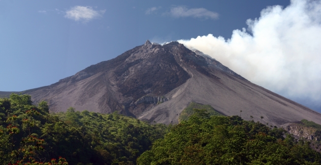
Mount Merapi, Gunung Merapi (literally Fire Mountain in Indonesian/Javanese), is an active stratovolcano located on the border between Central Java and Yogyakarta, Indonesia. It is the most active volcano in Indonesia and has erupted regularly since 1548. It is located approximately 28 kilometres (17 mi) north of Yogyakarta city, and thousands of people live on the flanks of the volcano, with villages as high as 1,700 metres (5,600 ft) above sea level.

The name Merapi could be loosely translated as ‘Mountain of Fire’. The etymology of the name came from Meru-Api; from the Javanese combined words; Meru means “mountain” refer to mythical mountain of Gods in Hinduism, and api means “fire”. Smoke can be seen emerging from the mountaintop at least 300 days a year, and several eruptions have caused fatalities. Hot gas from a large explosion killed 27 people on 22 November in 1994, mostly in the town of Muntilan, west of the volcano.[3] Another large eruption occurred in 2006, shortly before the Yogyakarta earthquake. In light of the hazards that Merapi poses to populated areas, it has been designated as one of the Decade Volcanoes.

On 25 October 2010 the Indonesian government raised the alert for Mount Merapi to its highest level and warned villagers in threatened areas to move to safer ground. People living within a 20 km (12.5 mile) zone were told to evacuate. Officials said about 500 volcanic earthquakes had been recorded on the mountain over the weekend of 23–24 October, and that the magma had risen to about 1 kilometre (3,300 ft) below the surface due to the seismic activity.[4] On the afternoon of 25 October 2010 Mount Merapi erupted lava from its southern and southeastern slopes.[5]

The mountain was still erupting on 30 November 2010 however due to lowered eruptive activity on 3 December 2010 the official alert status was reduced to level 3.[

Mythology

Merapi is very important to Javanese, especially those living around its crater. As such, there are many myths and beliefs attached to Merapi.

[edit] Creation

Although most nearby villages have their own myths about the creation of Mount Merapi, they have numerous commonalities. It is believed that when the gods had just created the Earth, Java was unbalanced because of the placement of Mount Jamurdipo on the west end of the island. In order to assure balance, the gods (generally represented by Batara Guru) ordered the mountain to be moved to the centre of Java. However, two armourers, Empu Rama and Empu Permadi, were already forging a sacred keris at the site where Mount Jamurdipo was to be moved. The gods warned them that they would be moving a mountain there, and that they should leave; Empu Rama and Empu Permadi ignored that warning. In anger, the gods buried Empu Rama and Empu Permadi under Mount Jamurdipo; their spirits later became the rulers of all mystical beings in the area. In memory of them, Mount Jamurdipo was later renamed Mount Merapi, which means “fire of Rama and Permadi.”[7]

Spirit Kraton of Merapi

The Javanese believe that the Earth is not only populated by human beings, but also by spirits (makhluk halus). Villages near Merapi believe that one of the palaces (in Javanese kraton) used by the rulers of the spirit kingdom lies inside Merapi, ruled by Empu Rama and Empu Permadi. This palace is said to be a spiritual counterpart to the Yogyakarta Sultanate, complete with roads, soldiers, princes, vehicles, and domesticated animals. Besides the rulers, the palace is said to also be populated by the spirits of ancestors who died as righteous people. The spirits of these ancestors are said to live in the palace as royal servants (abdi dalem), occasionally visiting their descendants in dreams to give prophecies or warnings. “[8]

Geological history

Merapi before 2007 eruption.

Merapi is the youngest in a group of volcanoes in southern Java. It is situated at a subduction zone, where the Indo-Australian Plate is sliding beneath the Eurasian Plate. It is one of at least 129 active volcanoes in Indonesia, part of the volcano is located in the Southeastern part of the Pacific Ring of Fire–a section of fault lines stretching from the Western Hemisphere through Japan and South East Asia.[9] Stratigraphic analysis reveals that eruptions in the Merapi area began about 400,000 years ago, and from then until about 10,000 years ago, eruptions were typically effusive, and the out flowing lava emitted was basaltic. Since then, eruptions have become more explosive, with viscous andesitic lavas often generating lava domes. Dome collapse has often generated pyroclastic flows, and larger explosions, which have resulted in eruption columns, have also generated pyroclastic flows through column collapse.

Merapi in 1930

Typically, small eruptions occur every two to three years, and larger ones every 10–15 years or so. Notable eruptions, often causing many deaths, have occurred in 1006, 1786, 1822, 1872, and 1930—when thirteen villages were destroyed and 1400 people killed by pyroclastic flows.

A very large eruption in 1006 is claimed to have covered all of central Java with ash. The volcanic devastation is claimed to have led to the collapse of the Hindu Kingdom of Mataram; however, there is insufficient evidence from that era for this to be substantiated.

2006 eruption

Pyroclastic flows (2006)

In April 2006, increased seismicity at more regular intervals and a detected bulge in the volcano’s cone indicated that fresh eruptions were imminent. Authorities put the volcano’s neighboring villages on high alert and local residents prepared for a likely evacuation. On 19 April smoke from the crater reached a height of 400 metres (1,300 ft), compared to 75 metres (246 ft) the previous day. On 23 April, after nine surface tremors and some 156 multifaced quakes signalled movements of magma, some 600 elderly and infant residents of the slopes were evacuated.[10]

By early May, active lava flows had begun. On 11 May, with lava flow beginning to be constant, some 17,000 people were ordered to be evacuated from the area[11] and on 13 May, Indonesian authorities raised the alert status to the highest level, ordering the immediate evacuation of all residents on the mountain.[12] Many villagers defied the dangers posed by the volcano and returned to their villages, fearing that their livestock and crops would be vulnerable to theft.[9] Activity calmed by the middle of May.[13]

On 27 May, a 6.3 magnitude earthquake struck roughly 50 km (30 miles) southwest of Merapi, killing at least 5,000 and leaving at least 200,000 people homeless in the Yogyakarta region, heightening fears that Merapi would “blow”.[14] The quake did not appear to be a long-period oscillation, a seismic disturbance class that is increasingly associated with major volcanic eruptions. A further 11,000 villagers were evacuated on 6 June as lava and superheated clouds of gas poured repeatedly down its upper slopes towards Kaliadem, a location that was located southeast of Mt. Merapi.[15] The pyroclastic flows are known locally as “wedhus gembel” (Javanese for “shaggy goat”). There were two fatalities as the result of the eruption.

2010 eruption

Destroyed house in Cangkringan Village after the eruptions

In late October 2010 the Center for Volcanology and Geological Hazard Mitigation, Geological Agency (CVGHM), (Indonesian language—Pusat Vulkanologi & Mitigasi Bencana Geologi, Badan Geologi-PVMBG), reported that a pattern of increasing seismicity from Merapi had begun to emerge in early September.

Observers at Babadan 7 kilometres (4.3 mi) west and Kaliurang 8 kilometres (5.0 mi) south of the mountain reported hearing an avalanche on 12 September 2010. On 13 September 2010 white plumes were observed rising 800 metres (2,600 ft) above the crater. Lava dome inflation, detected since March, increased from background levels of 0.1 millimetres (0.0039 in) to 0.3 millimetres (0.012 in) per day to a rate of 11 millimetres (0.43 in) per day on 16 September. On 19 September 2010 earthquakes continued to be numerous, and the next day CVGHM raised the Alert Level to 2 (on a scale of 1–4).[16] Lava from Mount Merapi in Central Java began flowing down the Gendol River on 23–24 October signalling the likelihood of an imminent eruption.[17]

On 25 October 2010 the Indonesian government raised the alert for Mount Merapi to its highest level (4) and warned villagers in threatened areas to move to safer ground. People living within a 10 kilometres (6.2 mi) zone were told to evacuate. The evacuation orders affected at least 19,000 people; however, the number that complied at the time remained unclear to authorities.[18] Officials said about 500 volcanic earthquakes had been recorded on the mountain over the weekend of 23–24 October, and that the magma had risen to about 1 kilometre (3,300 ft) below the surface due to the seismic activity[19]

After a period of multiple eruptions considered to exceed the intensity and duration of those in 1872[20] on 10 November 2010 the intensity and frequency of eruptions was noticed to subside.[21] By this time 153 people had been reported to have been killed and 320,000 were displaced.[22] Later the eruptive activities again increased requiring a continuation of the Level 4 alert and continued provision of exclusion zones around the volcano.[23][24] By 18 November the death toll had increased to 275.[25] The toll had risen to 324 by 24 November and Syamsul Maarif, head of the National Disaster Mitigation Agency (BNPB) explained that the death toll had risen after a number of victims succumbed to severe burns and more bodies were found on the volcano’s slopes.[26]

In the aftermath of the more intensive eruptive activities in late November Yogyakarta’s Disaster Management Agency reported that there were about 500 reported cases of eruption survivors in Sleman district suffering from minor to severe psychological problems, and about 300 cases in Magelang.[27] By 3 December the death toll had risen to 353.[28]

On Friday 3 December 2010 the head of the National Disaster Management Agency (BNPB), Dr. Syamsul Maarif, M. Si, accompanied by the head of the Centre for Volcanology and Geological Hazard Mitigation CVGHM (PVMBG), Dr. Surono made a joint press release at the BNPB Command Post in Yogyakarta. As of 3 December 2010, at 09.00 am, the CVGHM (PVMBG) lowered the status of Mount Merapi to the level of “Caution Alert (Level III). They clarified that with this alert level the potential of hot ash clouds and projected incandescent material remained. The Geological Agency provided several recommendations including that there would be no community activities in the disaster prone areas and proclaimed an ongoing exclusion zone of 2.5 kilometres (1.6 mi) radius.[

Monitoring

Merapi Volcano 27 January 2007.

Merapi next to Merbabu 9 January 2008.

Mount Merapi is the site of a very active volcano monitoring program. Seismic monitoring began in 1924, with some of the volcano monitoring stations lasting until the present. The Babadan (northwest location), Selo (in the saddle between Merbabu and Merapi), and Plawangan monitoring stations have been updated with equipment over the decades since establishment. During the 1950s and early 1960s some of the stations were starved of equipment and funds, but after the 1970s considerable improvement occurred with the supply of new equipment. Some of the pre-1930 observation posts were destroyed by the 1930 eruption, and newer posts were re-located. Similarly after the 1994 eruption, the Plawangan post and equipment were moved into Kaliurang as a response to the threat of danger to the volcanological personnel at the higher point.

The eruption of 1930 was found to have been preceded by a large earthquake swarm. The network of 8 seismographs currently around the volcano allow volcanologists to accurately pinpoint the hypocentres of tremors and quakes.

A zone in which no quakes originate is found about 1.5 km below the summit, and is thought to be the location of the magma reservoir which feeds the eruptions.

Other measurements taken on the volcano include magnetic measurements and tilt measurements. Small changes in the local magnetic field have been found to coincide with eruptions, and tilt measurements reveal the inflation of the volcano caused when the magma chambers beneath it is filling up.

Lahars (a type of mudflow of pyroclastic material and water) are an important hazard on the mountain, and are caused by rain remobilizing pyroclastic flow deposits. Lahars can be detected seismically, as they cause a high-frequency seismic signal. Observations have found that about 50 mm of rain per hour is the threshold above which lahars are often generated.

To keep the volcano quiet and to appease the spirits of the mountain, the Javanese regularly bring offerings on the anniversary of the sultan of Yogyakarta‘s coronation.[30] For Yogyakarta Sultanate, Merapi holds significant cosmological symbolism, because it is forming a sacred north-south axis line between Merapi peak and Southern Ocean (Indian Ocean). The sacred axis is signified by Merapi peak in the north, the Tugu monument near Yogyakarta main train station, the axis runs along Malioboro street to Northern Alun-alun (square) across Keraton Yogyakarta (sultan palace), Southern Alun-alun, all the way to Bantul and finally reach Samas and Parangkusumo beach on the estuary of Opak river and Southern Ocean. This sacred axis connected the hyangs or spirits of mountain revered since ancient times—often identified as “Mbah Petruk” by Javanese people—The Sultan of Yogyakarta as the leader of the Javanese kingdom, and Nyi Roro Kidul as the queen of the Southern Ocean, the female ocean deity revered by Javanese people and also mythical consort of Javanese kings

Sabo Dam

There are about 90 units (30 percent) from the total 258 units of sand barriers (sabo) were damaged. The cost for recovery is about Rp.1 trillion ($116 million).[32]

[edit] National park

In 2004 an area of 6,410 hectares around Mount Merapi was established as a national park. The decision of the Ministry of Forestry to declare the park has been subsequently challenged in court by The Indonesian Forum for Environment, on grounds of lack of consultation with local residents.[33] During the 2006 eruption of the volcano it was reported that many residents were reluctant to leave because they feared their residences would be confiscated for expanding the national park.[34]

Museum

  • Merapi Museum Center, Kaliurang Street Kilometer 25.7, Pakem subdistrict, Sleman, Yogyakarta. Replica of Merapi’s Post 2010 Eruption has been done and student’s visit to the museum had increased 30 percent since the latest eruption.[

Sendang Gile Water Fall

Standard
Sendang Gile Water Fall

Sendang Gile Water Fall

Sendang Gila waterfall

From Wikipedia, the free encyclopedia
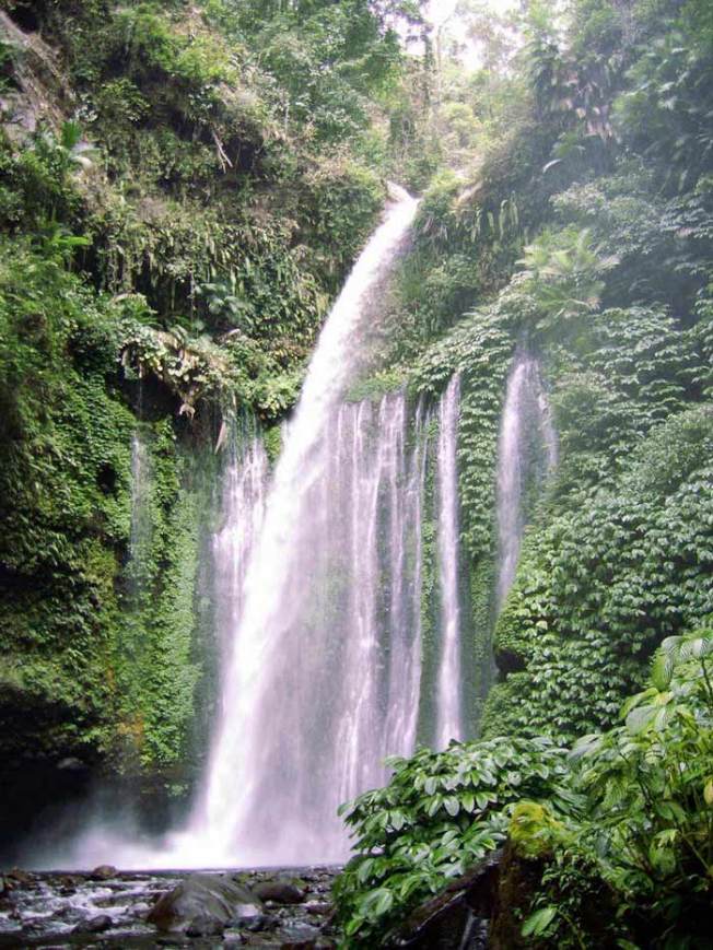
Sendang Gila waterfall (Sendang Gile), which attracts many thousands of Indonesian and foreign visitors annually, is Mount Rinjani national park’s best known attraction. Located at about 600m above sea level, the waterfall is an easy 20 minute walk down a graded trail and steps from Senaru Village, which is the main access to Mt. Rinjani National Park. A pleasant alternative return route winds along the edge of the steep valley, following the irrigation canal. For the more adventurous, the “second waterfall” Tiu Kelep, is another hour’s walk upriver from Sendang Gila. The scramble over rocks through the tropical forest is rewarded by the beauty of the waterfall and a swim in its deep pool. It is said locally that every time you swim behind the main waterfall of Tiu Kelep you become a year younger! With access from the main road, the “third waterfall” Betara Lenjang is a true rainforest adventure strictly for rock climbers with local guide and equipment.


Lake Toba

Standard
Lake Toba

Lake Toba

Lake Toba

From Wikipedia, the free encyclopedia
Lake Toba (IndonesianDanau Toba) is a lake and supervolcano. The lake is 100 kilometres long and 30 kilometres wide, and 505 metres (1,666 ft) at its deepest point. Located in the middle of the northern part of the Indonesian island of Sumatra with a surface elevation of about 900 metres (2,953 ft), the lake stretches from 2.88°N 98.52°E to 2.35°N 99.1°E. It is the largest lake in Indonesia and the largestvolcanic lake in the world.[1]

Lake Toba is the site of a supervolcanic eruption that occurred 69,000-77,000 years ago,[2][3][4] a massive, climate-changing event. The eruption is believed to have had a VEI intensity of 8. It is believed to be the largest explosive eruption anywhere on Earth in the last 25 million years. According to the Toba catastrophe theory to which some anthropologists and archeologists subscribe, it had global consequences, killing most humans then alive and creating a population bottleneck in Central Eastern Africa and India that affected the genetic inheritance of all humans today.[5] This theory however, has been largely debated as there is no evidence for any other animal decline or extinction, even in environmentally sensitive species.[6] However, it has been accepted that the eruption of Toba led to a volcanic winter with a worldwide decline in temperatures between 3 to 5 °C (5 to 9 °F), and up to 15 °C (27.0 °F) in higher latitudes.

Geology

The Toba caldera complex in Northern Sumatra, Indonesia consists of four overlapping volcanic craters that adjoin the Sumatran “volcanic front”. The youngest and fourth caldera is the world’s largest Quaternary caldera (100 km (62 mi) by 30 km (19 mi)) and intersects the three older calderas. An estimate of 2,800 km3 (670 cu mi) of dense-rock equivalent pyroclastic material, known the Youngest Toba tuff, was blasted from the youngest caldera during one of the largest single explosive volcanic eruptions in geologic history. Following the “Youngest Toba tuff eruption”, a typical resurgent dome formed within the new caldera, joining two half-domes separated by a longitudinal graben.[3]

There are at least four cones, four stratovolcanoes and three craters visible in the lake. The Tandukbenua cone on the NW edge of the caldera is relatively lacking in vegetation, suggesting a young age of only several hundred years. Also, the Pusubukit volcano on the south edge of the caldera is solfatarically active.[7]


The eruption

Location of Lake Toba shown in red on map.

The Toba eruption (the Toba event) occurred at what is now Lake Toba about 67,500 to 75,500 years ago.[8] The Toba eruption was the latest of a series of at least three caldera-forming eruptions which have occurred at the volcano, with earlier calderas having formed around 700,000 and 840,000 years ago.[9] The last eruption had an estimated Volcanic Explosivity Index of 8 (described as “mega-colossal”), making it possibly the largest explosive volcanic eruption within the last 25 million years.

Bill Rose and Craig Chesner of Michigan Technological University have deduced that the total amount of erupted material was about 2,800 km3(670 cu mi)[10] — around 2,000 km3 (480 cu mi) of ignimbrite that flowed over the ground, and around 800 km3 (190 cu mi) that fell as ash, with the wind blowing most of it to the west. The pyroclastic flows of the eruption destroyed an area of 20,000 square kilometres (7,722 sq mi), with ash deposits as thick as 600 metres (1,969 ft) by the main vent.[10]

To give an idea of its magnitude, consider that although the eruption took place in Indonesia, it deposited an ash layer approximately 15 cm (5.9 in) thick over the entire South Asia; at one site in central India, the Toba ash layer today is up to 6 m (20 ft) thick[11] and parts of Malaysia were covered with 9 m (30 ft) of ashfall.[12] In addition it has been variously calculated that 10,000 millionmetric tons of sulphuric acid[13][citation needed] or 6,000 million tons of sulphur dioxide[14] were ejected into the atmosphere by the event, causing acid rain fallout.

The Toba caldera is the only supervolcano in existence that can be described as Yellowstone’s “bigger” sister. With 2,800 km3 (670 cu mi) of ejecta, it was an even greater eruption than the supereruption (2,500 km3) of 2.1 million years ago that created the Island Park Caldera in Idaho, USA. The eruption was also about three times the size of the latest Yellowstone eruption of Lava Creek 630,000 years ago. For further comparison, the largest volcanic eruption in historic times, in1815 at Mount Tambora (Indonesia), ejected the equivalent of around 100 km3 (24 cu mi) of dense rock and made 1816 the “Year Without a Summer” in the whole northern hemisphere, whilst the 1980 eruption of Mount St. Helens in Washington State ejected around 1.2 km3 (0.29 cu mi) of material. The largest known eruption since the Toba event, the Oruanui eruption in New Zealand around 24,500 BC, ejected the equivalent of 530 km3of magma.

The subsequent collapse formed a caldera that, after filling with water, created Lake Toba. The island in the center of the lake is formed by a resurgent dome.

Landsat photo of Sumatra surrounding Lake Toba

Though the year may never be precisely determined, the season can: only the summer monsoon could have deposited Toba ashfall in the South China Sea, implying that the eruption took place sometime during the northern summer.[15] The eruption lasted perhaps two weeks, but the ensuing “volcanic winter” resulted in a decrease in average global temperatures by 3 to 3.5 degrees Celsius for several years. Greenland ice cores record a pulse of starkly reduced levels of organic carbon sequestration. Very few plants or animals in southeast Asia would have survived, and it is possible that the eruption caused a planet-wide die-off.

There is some evidence, based on mitochondrial DNA, that the human race may have passed through a genetic bottleneck around this time, reducing genetic diversity below what would be expected from the age of the species. According to the Toba catastrophe theory proposed by Stanley H. Ambrose of the University of Illinois at Urbana-Champaign in 1998, human populations may have been reduced to only a few tens of thousands of individuals by the Toba eruption.[16]


More recent activity

Smaller eruptions have occurred at Toba since. The small cone of Pusukbukit has formed on the southwestern margin of the caldera and lava domes. The most recent eruption may have been at Tandukbenua on the northwestern caldera edge, since the present lack of vegetation could be due to an eruption within the last few hundred years.[17]

Some parts of the caldera have experienced uplift due to partial refilling of the magma chamber, for example pushing Samosir Island and the Uluan Peninsula above the surface of the lake. The lake sediments on Samosir Island show that it has been uplifted by at least 450 metres (1,476 ft)[9] since the cataclysmic eruption. Such uplifts are common in very large calderas, apparently due to the upward pressure of unerupted magma. Toba is probably the largest resurgent caldera on Earth. Large earthquakes have occurred in the vicinity of the volcano more recently, notably in 1987 along the southern shore of the lake at a depth of 11 km (6.8 mi).[18] Other earthquakes have occurred in the area in 1892, 1916, and 1920-1922.[9]

Lake Toba lies near the Great Sumatran fault which runs along the centre of Sumatra in the Sumatra Fracture Zone.[9] The volcanoes of Sumatra and Java are part of the Sunda Arc, a result of the northeasterly movement of the Indo-Australian Plate which is sliding under the eastward-moving Eurasian Plate. The subduction zone in this area is very active: the seabed near the west coast of Sumatra has had several major earthquakes since 1995, including the 9.1 2004 Indian Ocean Earthquake and the 8.7 2005 Sumatra earthquake, the epicenters of which were around 300 km (190 mi) from Toba.

On 12 September 2007, a magnitude 8.5 Earthquake shook the ground in Sumatra and was felt in the Indonesian capital, Jakarta. The epicenter for this earthquake was not as close as the previous two earthquakes, but it was in the same vicinity.

On 26 October 2010, a magnitude 7.7 earthquake occurred 36 kilometers (22 miles) southwest of the nearby island of Pagai-selatan. A 10 foot (three-meter) tsunami immediately followed the temblor.

Eruption prospect

The 2004 earthquake physically rolled the Sumatran island and altered the shape of the Earth as was detected by the GRACE satellite. Recent highly-localized earthquake activity may initiate magmatic activity of this colossal global climate modifier.

People

Most of the people who live around Lake Toba are ethnically Bataks. Traditional Batak houses are noted for their distinctive roofs (which curve upwards at each end, as a boat’s hull does) and their colorful decor.[19]

[edit]Flora and fauna

The flora of the lake includes various types of phytoplankton, emerged macrophytes, floating macrophytes, and submerged macrophytes, while the surrounding countryside is rainforest including areas of Sumatran tropical pine forests on the higher mountainsides.[20]

Fauna include several variations of zooplankton and benthos animals. Lake Toba offers a nurturing environment for fish such as Tilapia mossambica,Aplocheilus panchaxLebistes reticulatusOsphronemus goramyTrichogaster trichopterusChanna striataChanna gachuaClarias batrachus,Clarias nieuhofiiClarias sp.Nemacheilus fasciatusCyprinus carpioPuntius javanicusPuntius binotatusOsteochilus nasseltiLissochilus sp.,Labeobarbus sora, and Rasbora sp..[20]


Prambanan part 2

Standard

Prambanan Temple Part2


Prambanan

The legend

The popular legend of Loro Jonggrang is what connects the site of the Ratu Boko Palace, the origin of the Durga statue in northern cell/chamber of the main shrine, and the origin of theSewu temple temple complex nearby. The legend tells of the story about Prince Bandung Bondowoso who fell in love with Princess Loro Jonggrang, the daughter of King Boko. But the princess rejected his proposal of marriage because Bandung Bondowoso had killed King Boko and ruled her kingdom. Bandung Bondowoso insisted on the union, and finally Loro Jonggrang was forced to agree for a union in marriage, but she posed one impossible condition: Bandung must build her a thousand temples in only one night.

The Prince entered into meditation and conjured up a multitude of spirits (demons) from the earth. Helped by supernatural beings, he succeeded in building 999 temples. When the prince was about to complete the condition, the princess woke her palace maids and ordered the women of the village to begin pounding rice and set a fire in the east of the temple, attempting to make the prince and the spirits believe that the sun was about to rise. As the cocks began to crow, fooled by the light and the sounds of morning time, the supernatural helpers fled back into the ground. The prince was furious about the trick and in revenge he cursed Loro Jonggrang to stone. She became the last and the most beautiful of the thousand statues. According to the traditions, the unfinished thousandth temple created by the demons become the Sewu temple compounds nearby (Sewu means “thousands” in Javanese), and the Princess is the image of Durga in the north cell of the Shiva temple at Prambanan, which is still known as Loro Jonggrang or Slender Virgin.

Other temples around Prambanan

Temples and archaeological sites in Prambanan Plain

The Prambanan Plain span between southern slopes of Merapi volcano in the north and Sewu mountain range in the south, near the present border Yogyakarta province and Klaten Regency, Central Java. Apart from the Lara Jonggrang complex, Prambanan plain, valley and hills around it is the location of some of the earliest Buddhist temples in Indonesia. Not far to the north are found the ruins of Bubrah temple, Lumbung temple, and Sewu temple. Further east are found Plaosan temple. To the west are found Kalasan temple and Sari temple, further to the west are Sambisari temple. While to the south the Ratu Boko compounds on higher ground. The discoveries of archaeological sites scattered only a few miles away suggested that this area was an important religious, political, and urban center.

North of the Lara Jongrang complex

  • Candi Lumbung. Buddhist-style, consisting of one main temple surrounded by 16 smaller ones.
  • Candi Bubrah. Buddhist temple still in ruins.
  • Sewu. Buddhist temple complex, older than Roro Jonggrang. A main sanctuary surrounded by many smaller temples. Well preserved guardian statues, replicas of which stand in the central courtyard at the Jogja Kraton.
  • Candi Morangan. Hindu temple complex buried several meters under volcanic ashes, located northwest from Prambanan.

Candi Plaosan in Prambanan (9th century).

  • Candi Plaosan. Buddhist, probably 9th century. Thought to have been built by a Hindu king for his Buddhist queen. Two main temples with reliefs of Boddhisatva and Tara. Also rows of slender stupas.

South of the Lara Jongrang complex

  • Ratu Boko. Complex of fortified gates, bathing pools, and elevated walled stone enclosure, all located on top of the hill.
  • Sajiwan. Buddhist temple decorated with reliefs concerning education. The base and staircase are decorated with animal fables.
  • Banyunibo. A Buddhist temple with unique design of roof.
  • Candi Barong. A Hindu temple complex with large stepped stone courtyard. Located on the slope of the hill.
  • Candi Ijo. A cluster of Hindu temple located near the top of Ijo hill. The main temple houses a large lingam and yoni.
  • Arca Bugisan. Seven Buddha and bodhisattva statues, some collapsed, representing different poses and expressions.

West of the Lara Jongrang complex

  • Kalasan. 8th century Buddhist temple built in commemoration of the marriage of a king and his princess bride, ornamented with finely carved reliefs.
  • Sari. Once a sanctuary for Buddhist priests. 8th century. Nine stupas at the top with two rooms beneath, each believed to be places for priests to meditate.
  • Sambisari. 9th century Hindu temple discovered in 1966, once buried 6.5 metres under volcanic ash. The main temple houses a linga and yoni, and the wall surround it displayed the images of Agastya, Durga, and Ganesha.
  • Gebang. A small Hindu temple discovered in 1937 located near the Yogyakarta northern ring-road. The temple display the statue of Ganesha and interesting carving of faces on the roof section.
  • Candi Gana. Rich in statues, bas-reliefs and sculpted stones. Frequent representations of children or dwarfs with raised hands. Located in the middle of housing complex. Under restoration since 1997.
  • Candi Kedulan. Discovered in 1994 by sand diggers, 4m deep. Square base of main temple visible. Secondary temples not yet fully excavated.

Prambanan Temple

Standard
Prambanan Temple

Prambanan Temple

Prambanan is a ninth century Hindu temple compound in Central JavaIndonesia, dedicated to the Trimurti, the expression of God as the Creator (Brahma), the Sustainer (Vishnu) and the Destroyer (Shiva). The temple compound is located approximately 18 km east ofYogyakarta city on the boundary between Yogyakarta and Central Java province.[1]

The temple, a UNESCO World Heritage Site, is the largest Hindu temple in Indonesia, and is one of the largest Hindu temples in south-east Asia. It is characterised by its tall and pointed architecture, typical of Hindu temple architecture, and by the towering 47m high central building inside a large complex of individual temples.

History

[edit]Construction

Prambanan is the largest Hindu temple of ancient Java, and the construction of this royal temple was probably started by Rakai Pikatan as the Hindu Sanjaya Dynasty’s answer to the Buddhist Sailendra Dynasty’s Borobudur and Sewu temples nearby. Historians suggest that the construction of Prambanan probably was meant to mark the return of the Hindu Sanjaya Dynasty to power in Central Java after almost a century of Buddhist Sailendra Dynasty domination. Nevertheless, the construction of this massive Hindu temple signifies that the Medangcourt had shifted the focus of its patronage from Mahayana Buddhism to Shivaist Hinduism.

A temple was first built at the site around 850 CE by Rakai Pikatan and expanded extensively by King Lokapala and Balitung Maha Sambu the Sanjaya king of the Mataram Kingdom. According to the Shivagrha inscription of 856 CE, the temple was built to honor Lord Shiva and its original name was Shiva-grha (the House of Shiva) or Shiva-laya (the Realm of Shiva).[2] Indeed, some archaeologists propose that the statue of Shiva in the garbhagriha (central chamber) of the main temple is modelled after King Balitung, serving as a depiction of his deified self after death.[3] The present name Prambanan, was derived from the name of Prambanan village where the temple stood, this name probably being the corrupted Javanesepronunciation of “Para Brahman” (“of the brahmins“), doubtless an echo its heyday when the temple was filled with great numbers of brahmins.

The temple compound was expanded by successive Mataram kings such as Daksa and Tulodong with the addition of hundreds of perwara temples around the chief temple. Prambanan served as the royal temple of the Hindu Kingdom of Mataram, with most of the state’s religious ceremonies and sacrifices being conducted there. At the height of the Mataram kingdom, scholars estimate that hundreds of brahmins with their disciples lived within the outer wall of the temple compound. The urban center and the court of Mataram were located nearby, somewhere in the Prambanan Plain.

Abandonment

In the 930s, the court was shifted to East Java by Mpu Sindok, who established the Isyana Dynasty. An eruption of Mount Merapi volcano, located north of Prambanan in central Java, or a power struggle probably caused the shift. That marked the beginning of the decline of the temple. It was soon abandoned and began to deteriorate.

The temples themselves collapsed during a major earthquake in the 16th century. Although the temple ceased to be an important center of worship, the ruins scattered around the area were still recognizable and known to the local Javanese people in later times. The statues and the ruins become the theme and the inspiration for the Loro Jonggrang folktale. After the division of Mataram Sultanate in 1755, the temple ruins and the Opak River were used to demarcate the boundary between Yogyakarta and Surakarta (Solo) Sultanates.

Rediscovery

The ruins of Prambanan soon after their discovery.

In 1811 during Britain’s short-lived rule of the Dutch East IndiesCollin Mackenzie, a surveyor in the service of Sir Thomas Stamford Raffles, came upon the temples by chance. Although Sir Thomas subsequently commissioned a full survey of the ruins, they remained neglected for decades, with Dutch residents carting off sculptures as garden ornaments and native villagers using the foundation stones for construction material.

Half-hearted excavations by archaeologists in the 1880s merely facilitated looting. Reconstruction of the compound began in 1918, and proper restoration only in 1930. Efforts at restoration continue to this day. The main building was completed around 1953. Since much of the original stonework has been stolen and reused at remote construction sites, hampering restoration and since a temple can be rebuilt only if at least 75% of the original masonry is available, only the foundations of most of the smaller shrines are now visible with no plans for their reconstruction.

Contemporary events

Prambanan nightview from the Trimurti open-air stage.

Ramayana dance performance in Prambanan.

In the early 1990s the government removed the market that had sprung up near the temple and transformed the surrounding villages and rice paddies into an archaeological park. The park covers a large area, from Yogyakarta-Solo main road in the south, encompassing the whole Prambanan complex, the ruins of Lumbung and Bubrah temples, and as far as the Sewu temple compound in the north. In 1992 the Indonesian government created a State-owned Limited Liability Enterprise (PERSERO) of PT Taman Wisata Candi Borobudur, Prambanan, dan Ratu Boko. This enterprise is the authority for the park management of Borobudur Prambanan Ratu Boko and the surrounding region.

The open-air and indoor stages on the west side of the temple right across the Opak river, were built to stage the Ramayana ballet. This traditional Javanese dance is the centuries old dance of the Javanese court, performed every full moon night in the Prambanan temple since the 1960s. Since then, Prambanan has become one of the major archaeological and cultural tourism attractions in Indonesia.

After the reconstruction of the main temples in 1990s, Prambanan once again reclaim its status as an important religious center for Hindurituals and ceremonies in Java. The religious significance revival of Prambanan was due to Balinese and Javanese Hindu communities in Yogyakarta and Central Java that annually perform their sacred ceremonies in Prambanan, such as GalunganTawur Kesanga, and Nyepi.[4][5]

The temple was damaged during the May 2006 Java earthquake. Early photos suggested that although the complex was structurally intact, the damage was significant. Large pieces of debris, including carvings, were scattered over the ground. The temple was closed to visitors until the damage could be fully assessed. Eventually, the head of Yogyakarta Archaeological Conservation Agency stated that it would take months to identify the precise extent of the damage.[6][7] However, some weeks later in 2006 the site was re-opened for visitors. As of 2009, the interior of most of the temples remains off-limits for safety reasons.

Roro Jonggrang complex

This information does not take account of damage caused by the 2006 Java earthquake

The statue of Durga Mahisasuramardini in northern cella of Shiva temple.

The temple compound.

The Prambanan compound also known as Loro Jonggrang complex, named after the popular legend of Loro Jonggrang. There are 237 temples in this Shivaite temple complex, either big or small.[8] But the majority of them have deteriorated, what is left are only scattered stones. The Prambanan temple complex consists of three zones; first the outer zone, second the middle zone that contains hundreds of small temples, and third the holiest inner zone that contains eight main temples and eight small shrines.

The outer zone is a large space marked by a rectangular wall (destroyed). The original function is unknown; possibilities are that it was a sacred park, or priests’ boarding school (ashram). The supporting buildings for the temple complex were made from organic material; as a consequence no remains occur.

Pervara Temples

The middle zone consists of four rows of 224 individual small shrines. There are great numbers of these temples, but most of them are still in ruins and only some have been reconstructed. These concentric rows of temples were made in identical design. Each row towards the center is slightly elevated. These shrines are called “Candi Perwara” guardian or complementary temples, the additional buildings of the main temple. Some believed it was offered to the king as a sign of submission. The Perwara are arranged in four rows around the central temples, some believed it has something to do with four castes, made according to the rank of the people allowed to enter them; the row nearest to the central compound was accessible to the priests only, the other three were reserved for the nobles, the knights, and the simple people respectively. While another believed that the four rows of Perwara has nothing to do with four castes, it just simply made as meditation place for priests and as worship place for devotees.

Shiva Temple

The inner zone or central compound is the holiest among the three zones. Its the square elevated platform surrounded by square stone wall with stone gates on each four cardinal points. This holiest compound is assembled of eight main shrines or candi. The three main shrines, called Trimurti (“three forms”), are dedicated to the three gods: Brahma the CreatorVishnu the Keeper, andShiva the Destroyer.

The Shiva temple is the tallest and largest structure in Prambanan Loro Jonggrang complex, it measures 47 metres tall and 34 metres wide. The Shiva temple encircled with galleries adorned with bas-reliefs telling the story of Ramayana carved on the inner walls of the balustrades. To follow the story accordingly, visitors must enter from the east side and began to perform pradakshina or circumambulating clockwise. The bas-reliefs of Ramayana continued to Brahma temple galleries.

The Shiva shrine located at the center and contains five chambers, four small chambers in every cardinal direction and one bigger main chamber in central part of the temple. The east chamber connect to central chamber that houses the largest temple in Prambanan, a three meter high statue of Shiva Mahadeva (the Supreme God). The statue bears Lakçana (attributes or symbol) of Shiva such as skull and sickle (crescent) at the crown, and third eye on the forehead, also four hands that holds Shiva’s symbols: a prayer beads, feather duster, and trisula (trident). Some historians believe that the depiction of Shiva as Mahadeva also meant to personify king Balitung as the reincarnation of Shiva. So, when he died, a temple was built to commemorate him as Shiva.[9] The statue of Shiva stands on lotus pad on Yoni pedestal that bears the carving of Nāga serpents on north side of pedestal.

The other three smaller chambers contain statues of Hindu Gods related to Shiva; his consort Durga, the rishi Agastya, and Ganesha, his son. Statue of Agastya occupy the south chamber, the west chamber houses the statue of Ganesha, while the north chamber contains the statue of Durga Mahisasuramardini depicting Durga as the slayer of Bull demon. The shrine of Durga is also called the temple of Lara Jonggrang (Javanese: slender virgin), after a Javanese legend of princess Lara Jonggrang.

Brahma and Vishnu temple

The two other main shrines are that of Vishnu on the north side of Shiva shrine, and the one of Brahma on the south. Both temple facing east and each contain only one large chamber, each dedicated to respected gods; Brahma temple contains the statue of Brahma and Vishnu temple houses the statue of Vishnu. Brahma and Vishnu temple measures 20 metres wide and 33 metres tall.

The bas-reliefs along the balustrades on the gallery around Shiva and Brahma temple depict the Ramayana legend. They illustrate how Sita, the wife of Rama, is abducted by Ravana. The monkey king Hanuman brings his army to help Rama and rescue Sita. This story is also shown by the Ramayana Ballet, regularly performed at full moon at Trimurti open air theatre in west side of the illuminated Prambanan complex. On the balustrades in Vishnu temple there is series of bas-relief depict Krishnayana, the story of lord Krishna.

Vahana Temple

The other three shrine in front of three main temples is dedicated to vehicle (vahana) of the respective gods – the bull Nandi for Shiva, the sacred swan Hamsa for Brahma, and Vishnu’s Eagle Garuda. Precisely in front of Shiva temple stands Nandi temple which contains a statue of Nandi bull, the vehicle (vahana) of Lord Shiva. Besides it, there is also other statues, the statue of Chandra the god of moon and Surya the god of sun. Chandra stands on his carriage pulled by 10 horses, and the statue of Surya also standing on a carriage pulled by 7 horses.[10]Facing Brahma temple is the temple of Hamsa or Angsa (sacred swan). In the chamber of this temple contains no statue. But it seems likely that there was once a statue of the sacred swan, vehicle of god Brahma. In front of Vishnu temple is the temple dedicated for Garuda, however just like the Hamsa temple, Garuda temple contains no statue. Probably this temple once contains the statue of Garuda, the vehicle of Vishnu. Garuda holds important role for Indonesia, which serves as the national symbol of Indonesia, also to the airline Garuda Indonesia.

Between these row of main temple, on north and south side stands two Candi Apit. Beside these 8 main temples, there’s also 8 smaller shrines; 4 Candi Kelir on four cardinal direction of the entrance, and 4 Candi Patok on four corner.

Architecture

The cross section of Shiva temple

The architecture of Prambanan temple follows the typical Hindu architecture traditions based on Vastu Shastra. The temple design incorporated mandala temple plan arrangements and also the typical high towering spires of Hindu temples. Prambanan was originally named Shivagrha and dedicated to god Shiva. The temple was designed to mimic Meru, the holy mountain the abode of Hindu gods, and the home of Shiva. The whole temple complex is a model of Hindu universe according to Hindu cosmology and the layers of Loka.

Just like Borobudur, Prambanan also recognize the hierarchy of the temple zones, spanned from the less holy to the holiest realms. Each Hindu and Buddhist concepts has their own terms, but the concept’s essentials is identical. Either the compound site plan (horizontally) or the temple structure (vertically) are consists of three zones:[11]

  • Bhurloka (in Buddhism: Kāmadhātu), the lowest realm of common mortals; humans, animals also demons. Where humans still binded by their lust, desire and unholy way of life. The outer courtyard and the foot (base) part of each temples is symbolized the realm ofbhurloka.
  • Bhuvarloka (in Buddhism: Rupadhatu), the middle realm of holy people, rishis, ascetics, and lesser gods. People here began to see the light of truth. The middle courtyard and the body of each temples is symbolized the realm of bhuvarloka.
  • Svarloka (in Buddhism: Arupadhatu), the highest and holiest realm of gods, also known as svargaloka. The inner courtyard and the roof of each temples is symbolized the realm of svarloka. The roof of the Prambanan temples is adorned and crowned with ratna (sanskrit: jewel). In ancient Java temple architecture, ratna is Hindu counterpart of Buddhist stupa, and served as the temple’s pinnacle.

During the restoration, a well which contains pripih (stone casket) was discovered under the center of the Shiva temple. The main temple has a well of 5.75 m depth in which a stone casket was found on top a pile of charcoal, earth and remains of burned animal bones. Sheets of gold leaves with the inscription Varuna (god of the sea) and Parvata (god of the mountains) were found here. The stone casket contained sheets of copper mixed with charcoal, ashes and earth, 20 coins, jewels, glass, pieces of gold and silver leavesseashells and 12 gold leaves (5 of which in the shape of a turtle, Nāga serpent, padma, altar and egg).[12]


Lake Limbungan

Standard
lake limbungan(pict)

lake limbungan(pict)


Limbungan Lake, a hydroelectric dam was originally built for irrigation purposes is contained in an area surrounded by beautiful hills that have panoramic nature as a tourist attraction. Seeing this potential, the place was later developed as a tourist area which is equipped with various amenities and facilities for recreational purposes, such as various types of water bicycles, boats, restaurants, stage entertainment, playground, cottages and so forth. This recreational area is about 10 km from the center of Pekanbaru and can be reached by public transportation. Not far from here there is also a location as the arena motocross race. * Source: Enchantment Riau (Department of Culture, Arts and Tourism, Government of Riau Province)..


Borobudur The Bigest Temple

Standard
borobudur

borobudur

Borobudur, or Barabudur, is a 8th-century Mahayana Buddhist monument near Magelang,Central Java, Indonesia. The monument comprises six square platforms topped by three circular platforms, and is decorated with 2,672 relief panels and 504 Buddha statues.[1] A main dome, located at the center of the top platform, is surrounded by 72 Buddha statues seated inside perforated stupa.

The monument is both a shrine to the Lord Buddha and a place for Buddhist pilgrimage. The journey for pilgrims begins at the base of the monument and follows a path circumambulatingthe monument while ascending to the top through the three levels of Buddhist cosmology, namely Kāmadhātu (the world of desire), Rupadhatu (the world of forms) and Arupadhatu (the world of formlessness). During the journey the monument guides the pilgrims through a system of stairways and corridors with 1,460 narrative relief panels on the wall and thebalustrades.

Evidence suggests Borobudur was abandoned following the 14th-century decline of Buddhist and Hindu kingdoms in Java, and the Javanese conversion to Islam.[2] Worldwide knowledge of its existence was sparked in 1814 by Sir Thomas Stamford Raffles, then the British ruler of Java, who was advised of its location by native Indonesians. Borobudur has since been preserved through several restorations. The largest restoration project was undertaken between 1975 and 1982 by the Indonesian government and UNESCO, following which the monument was listed as a UNESCO World Heritage Site.[3] Borobudur is still used for pilgrimage; once a year Buddhists in Indonesia celebrate Vesak at the monument, and Borobudur is Indonesia’s single most visited tourist attraction.


Hello world!

Standard

Welcome to WordPress.com. After you read this, you should delete and write your own post, with a new title above. Or hit Add New on the left (of the admin dashboard) to start a fresh post.

Here are some suggestions for your first post.

  1. You can find new ideas for what to blog about by reading the Daily Post.
  2. Add PressThis to your browser. It creates a new blog post for you about any interesting  page you read on the web.
  3. Make some changes to this page, and then hit preview on the right. You can alway preview any post or edit you before you share it to the world.